
1833 Map Reveals Americans Lived In A Giant Eagle
MessageToEagle.com – In 1833, Americans lived in the United States of Eagle.
That year, an atlas, entitled Rudiments of National Knowledge, Presented to the Youth of the United States, and to Enquiring Foreigners, was published in Philadelphia. Written by Joseph Churchman, it was intended to “awaken in youth a just sense of our national advantages and blessings” by way of geographical information, anecdotes, and maps.
One of the more striking visuals created for the atlas was the “eagle map,” which depicted the United States with a giant bird superimposed on it. Churchman wrote in the atlas that the eagle—which looks more like a dove or pigeon than your standard, fierce bald eagle—was intended to be a “placid representative of national liberty.”
He envisioned a mythical backstory in which the bird had been in the Old World, became fed up with the oppression, conflict, and tyranny there, and then “taken its flight across the western ocean, in search of a resting place; where its administration of equal rights might be duly appreciated and respected.”
See also:
- Babylonian World Map
- Ancient Enigma Of Mercator’s Amazing Map
- World’s Oldest Moon Map Carved Into Ireland’s 5,000 Year-Old Tomb At Knowth
The eagle’s silhouette was drawn to align with the borders of the United States, which at the time did not yet extend westward of the territory acquired in the Louisiana Purchase. The bird’s chest formed the Atlantic seaboard, its wings extended to the western limits, and its talons curled around Florida.
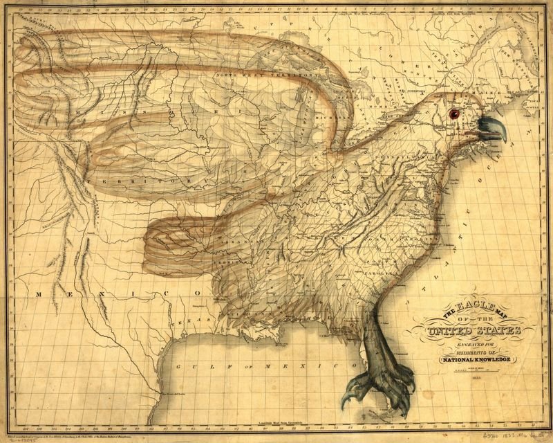
The only part of the country that was not incorporated into the bird was Maine. In the atlas, Churchman acknowledged this shortcoming, and explained to potentially disgruntled Maine residents that the mapmakers had designated the state as the eagle’s “cap of liberty.” On the map this supposed cap just looks like a squiggly line, but the purple prose-inclined Churchman couldn’t very well say, “Sorry, the awkward shape of your state would ruin our bad-ass eagle.”
MessageToEagle.com via Atlas Obscura
Related Posts
-
 Real-Life Excalibur Found Underwater In Bosnia – Medieval Sword In Stone Pulled Out
-
 This Is What The Siberian Princess Ukok Looked Like In Real Life
-
 Great Ruins of Zimbabwe: Unsolved Secrets Of Bizarre Buildings Without Windows And Doors
-
 2000-Year-Old Antikythera Mechanism – Experts Recreate A Mechanical Cosmos For The World’s First Computer
-
 Legendary Viking Sunstones Did Exist: Viking Sagas Were More Truthful Than We Realized
-
 Unique 1,000-Year-Old Medieval Golden Treasure Unearthed By Dutch Historian Using Metal Detector
-
 Why Was Pharaoh Hatshepsut’s Reign Virtually Erased From History?
-
 Tusayan Pueblo Ruins Tell Story Of Ancestral People Who Once Inhabited The Grand Canyon
-
 Mysterious Etruscan Stone Structures Hidden In The Malano Forest – Evidence Of Ancient Unknown High-Tech Knowledge?
-
 Unexplained Mystery Of The Untraceable Stone-Throwers – Strangeness In North America, Belgium And Indonesia – Part 1