
Tabula Peutingeriana: Huge Ancient Roman Map Created By Unknown Cartographer
MessageToEagle.com – The Tabula Peutingeriana is a huge, six meters long parchment scroll that depicts the road network of the Roman Empire. It is the only Roman world map that survived from antiquity.
The Tabula Peutingeriana, also known as “Peutinger Map”, has been dated to the twelfth or thirteenth century, but historians are convinced this is a copy of a much older original. The unknown cartographer used older sources, which date back to the first century.
A unique copy of the map is currently preserved at the National Library in Vienna.
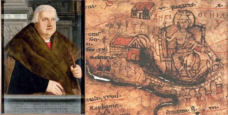
The map was discovered in a library in Worms by Conrad Celtes, who was unable to publish his find before his death and donated the map in 1508 to Konrad Peutinger, a German 15–16th-century humanist and antiquarian, after whom it is named.
It was passed around royal and elite families until it was bought by Prince Eugene of Savoy, and upon his death it was purchased by Vienna’s Austrian National Library where it has been kept since 1737.
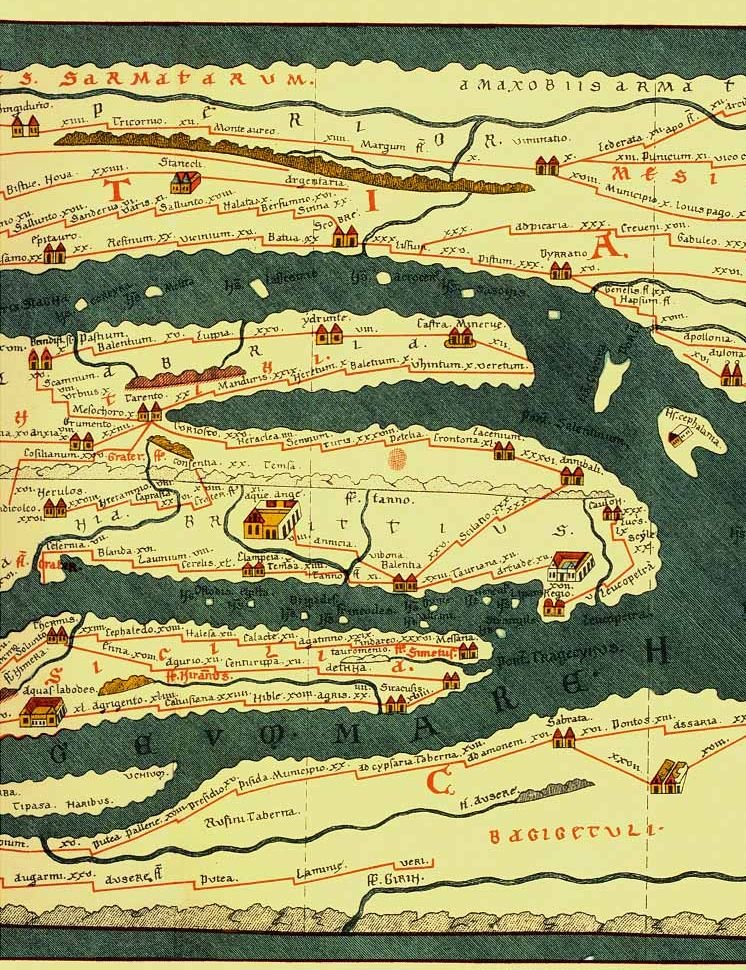
The very schematic map spans through Europe (minus Spain or the British Isles), North Africa and parts of Asia. The map shows many Roman settlements, the roads connecting them, rivers, mountains, forests and seas.
The distances between the settlements are also given and marked in Roman numerals indicating the miles or Gallic league (an ancient measurement, the original of the Old English mile).

Three most important cities of the Roman Empire, Rome, Constantinople and Antioch, are represented with special iconic decoration.
See also:
1833 Map Reveals Americans Lived In A Giant Eagle
Ancient Enigma Of Mercator’s Amazing Map
Besides the totality of the Empire, the map shows the Near East, India and the Ganges, Sri Lanka (Insula Taprobane), even an indication of China. In the west, the absence of the Iberian Peninsula indicates that a twelfth original section has been lost in the surviving copy.
In 2007, the map was placed on the UNESCO Memory of the World Register, and in recognition of this, it was displayed to the public for a single day on November 26, 2007. Due to its fragile condition, the Tabula Peutingeriana is not ordinarily on display.
The full map is shown here.
MessageToEagle.com
References:
Related Posts
-
 Robert Fortune’s Dangerous Mission To Obtain Tea From The Chinese
-
 Who Was The Mysterious Spitalfields Roman Noblewoman Dressed In Silk Found In A Sarcophagus In London?
-
 Cassandra: Greek Goddess Who Foretold Cursed Prophecies
-
 Caribbean Cannibalism Theory – Debunked By Researchers
-
 Ashurbanipal – Last Great Ruler Of Assyria And His Famous Well-Organized Library
-
 Art Historians Solve Mystery Of Rafael’s Tomb By Reconstructing His Face
-
 DNA Study Sheds New Light On Ancient Britain’s Language, Ancestry, Kinship, Milk
-
 Mysterious Gobi Sea And A Huge Land Inhabited By The Real Sons Of God
-
 Six Ancient Giant Stone Spheres Recovered From The Diquís Delta, Costa Rica
-
 Mysterious Teotihuacan ‘Host’ Figurines From Metepec, Mexico