Early Human Migration To Americas And Climate Change
Eddie Gonzales Jr. – MessageToEagle.com – Researchers have pinpointed two intervals when ice and ocean conditions would have been favorable to support early human migration from Asia to North America late in the last ice age, a new paper published today in the Proceedings of the National Academy of Sciences shows.
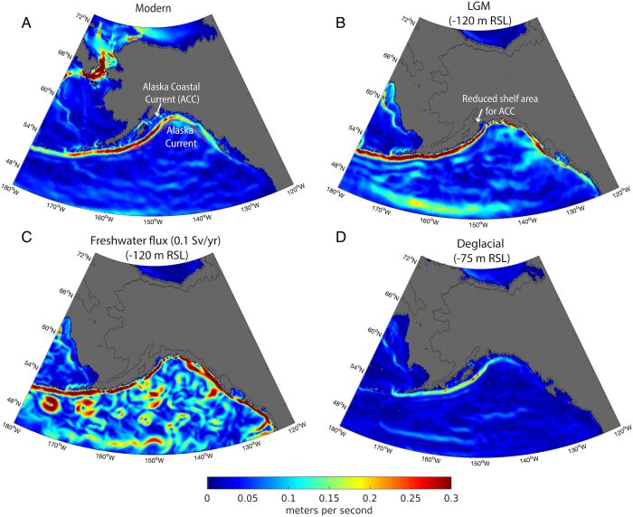
Simulations of ocean currents in the Northeast Pacific under different climate and sea level conditions: Modern climate state (A), LGM climate state, with sea level −120 m below modern (B), LGM boundary conditions with an increased freshwater flux (C), and intermediate sea level (−75 m), as would have occurred during the mid-deglacial period (D). Mean annual surface ocean velocity shows a strengthening of the cyclonic Alaska Current during the LGM relative to modern conditions, as well as a contraction of the shelf area on which the ACC flows. Boundary currents flow in a cyclonic (anticlockwise) direction. Credit: Proceedings of the National Academy of Sciences (2023). DOI: 10.1073/pnas.2208738120
The findings align with a growing body of evidence that the most likely path for the first Americans was a Pacific coastal route that was in use before the large ice sheets covering much of present-day Canada and parts of the U.S. began to retreat.
Using ocean modeling and data from sediment cores collected in the northeast Pacific Ocean, the researchers found two distinct climate intervals where a combination of winter sea ice and ice-free summer conditions likely would have facilitated migration further south toward the end of the last ice age,” Alan Mix, an oceanographer and paleoclimatologist at Oregon State University and a co-author of the paper, said in a press release.
“Our research indicates that during the last ice age, the ice along the west coast of North America, from Seattle to Alaska, moved back and forth quite a bit,” said Mix, a professor in OSU’s College of Earth, Ocean, and Atmospheric Sciences. “Surprisingly, there were times when ice didn’t block the way for those early people. In fact, some ice might have made migration easier.”
The paper’s lead author is Summer Praetorius, a research geologist at the U.S. Geological Survey who earned her doctorate at Oregon State. Praetorius and Mix have worked together on several projects using climate data from sediment cores.
Early Americans occupied part of Beringia, a land mass in the present-day Bering Strait that created a bridge between Asia and North America. The question of when and how early people moved south into the Americas from there is one researchers have been exploring for decades.
Much of the evidence of early peoples in the Americas is less than 13,000 years old and may have been left after the climate warmed and the mile-thick ice sheet retreated. That evidence led to a theory that the Americas were populated through an inland corridor that opened up as the ice sheet began to retreat.
But more recent evidence, including the discovery of 15,700-year-old projectile points by Oregon State anthropologist Loren Davis, indicates that people began arriving in the Americas well before the ice-free inland corridor opened up.
“The mounting evidence for human arrival prior to the opening of the ice-free corridor makes the coastal route the most likely pathway into North America,” Praetorius said. “We wanted to try and figure out how regional climate change affected the viability of the coastal route at different times. For example, understanding where and when sea ice formed in the Gulf of Alaska has implications for how people could move along the coastline—whether by foot or in boats.”
A high-resolution ocean model utilized by study co-author Alan Condron from Woods Hole Oceanographic Institution in Massachusetts indicated as ice from the edges of the Cordilleran ice sheet began to retreat, it drained a lot of fresh water into the ocean. That meltwater accelerated ocean currents moving north, which would have made boat travel heading south along the coast, between the spots of dry land, more difficult.
Sediment cores, which provide researchers important information about changing ocean and planet conditions over long periods of time, showed the presence of sea ice at key intervals that may have supported travel on foot.
The sediment cores, collected in the Gulf of Alaska, contained molecular traces of the remains of algae that grew around sea ice along the shoreline. In two intervals, from 22,000 to 24,500 years ago and again from 14,800 to 16,400 years ago, sea ice was present in the winter even as summer warmed, plausibly giving early Americans the opportunity to travel along the coast, the researchers said.
“Sea ice is relatively flat and pretty stable when it is stuck to the shoreline, so you can walk on the ice and hunt seals to survive through the winter,” Praetorius said. “It seems possible that sea ice could have facilitated movement, rather than hinder it, by providing a more traversable surface than the hazardous pathway of crevassed glaciers or paddling against strong ocean currents.”
Written by Eddie Gonzales Jr. – MessageToEagle.com Staff

