
Strangest Maps Ever Created – You Have Never Seen Our World Like This!
MessageToEagle.com – In ancient time people saw the world in a very different way. This collection of maps must be one of the strangest representation of world depictions ever created.
Some of these maps are fantasy. As you can see, the shape of the countries and continents are odd representations of figures or animals. Other maps depict what our ancestors believed to be Biblical Lands.
“Legends of strange human beings have a long history, as do their depictions on maps. Many of these representations were derived from the descriptions given in the Natural History of the World by the elder Pliny (AD 23-79) and first printed in Latin in 1469. Pliny’s ideas were absorbed by most geographers of the 16th century, and were particularly well illustrated in the successive editions of Ptolemy’s maps published by Sebastian Munster from 1540 onwards.
On the Ptolemaic map of Asia, a number of strange beings are placed in Scythia or part of Northern Asia.
At the top of the map Munster shows the Anthropophagi, who feed on men’s flesh and live near the North Pole.
In the margins he depicts those humans described by Pliny in Book 7:
“In India there is a kind of men with heads like dogs…who in lieu of speech use to bark.
Likewise there is a kind of people named monoscelli that have but one leg apiece.
In the hottest season of Summer they lie along their backe and defend themselves with their foot against the Sunnes heat.”
The last tribe shown, those with their faces below their shoulders, later reappear, as do the anthropophagi, in the New World of America, as legends of the Old World were transferred to the unexplored continent. Sir Walter Raleigh, in his description of Guiana, tells of the existence of a warrior tribe with their heads below their shoulders in the Orinoco basin and also describes the fierce Amazonian women.”
Then of course we have the legendary Garden of Eden. For over 1500 years the existence of the Garden of Eden was an unquestionable fact for most Christian believers. Its location varied, but in the early Middle Ages it was generally thought to be at the eastern extremity of the world, while later it was placed in the area of Mesopotamia.
Early map makers often recorded on their maps and charts the presence of fabulous beasts, many of which reveal themselves as identifiable species made grotesque by the embroidered tales of sailors and travelers. Of the many maps depicting sea monsters, the Carta Marina by Olaus Magnus was the most influential. First printed in 1539, it showed the area of the North Sea filled with dangerous maritime creatures. Versions of Olaus Magnus’s monsters populated the seas on charts until the mid-18th century.
See also:
Undeciphered Ancient Stone Maps With Mysterious Signs May Hold Key To The Spider Rock Treasure
Ancient Enigma Of Mercator’s Amazing Map
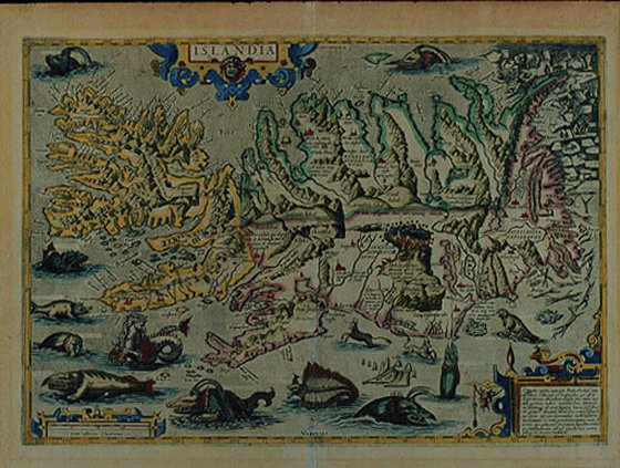
Ortelius copied many of these monsters for his map of Iceland, published in editions of his Theatrum Orbis Terrarum. Iceland is shown at large scale, with its fjords, glaciers, and mountains, including an erupting volcano, Mt. Hekla. Polar bears on icebergs can be seen at the top right, while the ocean contains probably the most fantastic collection of sea monsters to be seen on one engraving.
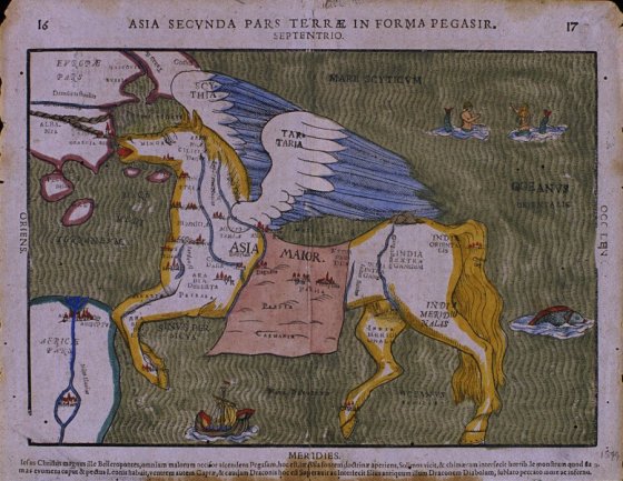
Among the earliest cartographic oddities are the famous maps from Heinrick Bunting’s Itinerarium Sacra Scripturae, or Travels According to the Scriptures, first published in 1581. A description of Biblical lands, it was a popular book that was reprinted many times. In addition to correct maps of the Holy Land, it also contained three maps of pure fantasy: the world in the form of a clover leaf, Europe as a robed female figure, and Asia as Pegasus the mythical winged horse.
The horse is drawn fairly realistically, so that the shape of Asia has to be adjusted; the Caspian Sea lies horizontally between the wings and the saddle, and modern India is the off hind leg. The Pegasus map can be found in a number of different editions in both woodcut (as displayed here) and more rare copperplate versions.
In Bunting’s map of the world as a clover leaf, representing the Trinity, each of the three continents of the Old World forms a section, with Jerusalem in a circle in the center. England and Scandinavia appear separately at the northern edge of the mpa, and the new continent of America can be seen in the lower left corner.
It has been suggested that the cloverleaf design represents not only the Trinity, but the arms of Bunting’s native city of Hanover.
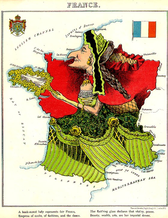
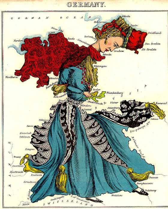
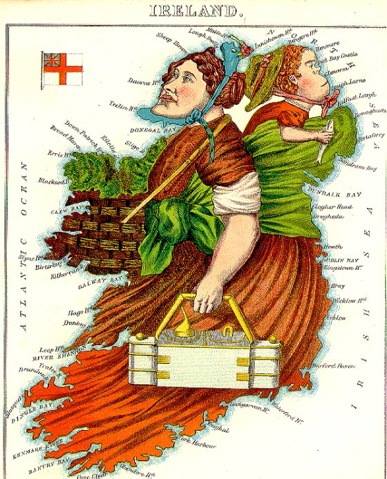
These maps are from Geographical Fun, or Humorous Outlines of Various Countries, published by Hodder and Stoughton in 1869. The author, William Harvey writing under the pseudonym Aleph, created a series of twelve maps showing various countries as curious people in the great tradition of English caricaturists. The idea behind the maps was taken from sketches drawn by a fifteen year old girl wishing to amuse her sick brother confined to bed.
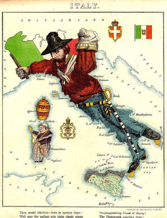
Harvey states in the introduction: “It is believed that illustrations of Geography may be rendered educational, and prove of service to young scholars who commonly think Globes and Maps but wearisome aids to knowledge.” The maps and rhymes were thus designed to amuse children and to teach some basic geographical concepts, rather than as political satires.
These maps are part of the Yale University Map Collection.
© MessageToEagle.com
Related Posts
-
 Traces Of Viking Raids Remain Visible In Modern Russian Economy And Politics
-
 Puzzling Sabaean Inscription Found On A Large Clay Jar Near The Jerusalem Temple Deciphered
-
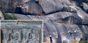 Barabar Caves: The Oldest Surviving Rock-Cut Caves In India
-
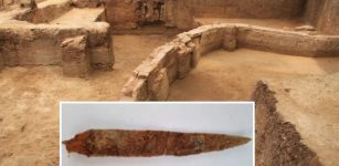 Rare Well-Preserved 2,500-Year-Old Dagger Linked To The Keeladi Civilization Discovered In Tamil Nadu, India
-
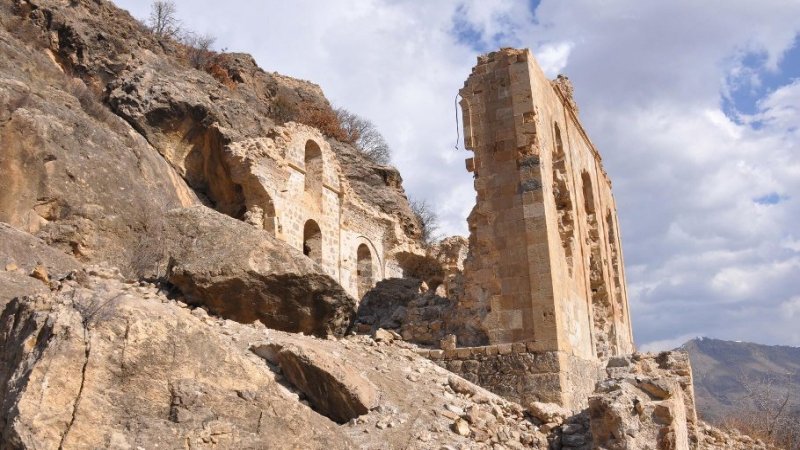 Orthodox Church In Black Sea Region Looted By Treasure Hunters
-
 How Can Busy People Also Keep Fit And Healthy? What The Ancient Greeks And Romans Did?
-
 Dearg-Due Frightening Female Demon And Tyrannical Abhartach Of Irish Folklore
-
 Ancient People In Peru Had A Unique Response To The Looting And Destruction Of Their Ancestors’ Graves
-
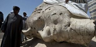 Remarkable Massive Statues Of Pharaoh Amenhotep III Discovered In Luxor
-
 Dark And Light Sides Of Pax Romana: Great Political Slogan Introduced After Civil Wars