
Giant Underground Mountains Revealed After Enormous Earthquake Struck Bolivia
MessageToEagle.com – Scientists report giant underground mountains have been discovered in Bolivia. The mountains located about 660 kilometers below our feet were revealed after an enormous earthquake struck the region. According to scientists, their statistical model didn’t allow for precise height measurements, but these mountains may be bigger than anything on the surface of the Earth.

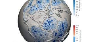
A study by Princeton scientists into the boundary between the upper and lower mantle of the Earth have surprisingly found topography potentially ‘rougher’ than any mountain on Earth. They are located at a boundary 410 miles (600 kilometers) straight down into the Earth from the planet’s surface. NOTE: This graphic is not to scale. Credit: Kyle McKernan, Office of Communications
The results of the study has been published by Princeton geophysicists Jessica Irving and Wenbo Wu, in collaboration with Sidao Ni from the Institute of Geodesy and Geophysics in China in Science.
As the researchers explain, the Earth has three (or four) layers: a crust, mantle and core, which is sometimes subdivided into an inner and outer core. However, it does leave out several other layers that scientists have identified within the Earth.
To peer deep into the Earth, scientists use the most powerful waves on the planet, which are generated by massive earthquakes. “You want a big, deep earthquake to get the whole planet to shake,” Irving, an assistant professor of geosciences Irving said in a press statement.
Big earthquakes are vastly more powerful than small ones and energy increases 30-fold with every step up the Richter scale. Deep earthquakes, “instead of frittering away their energy in the crust, can get the whole mantle going,” Irving said.
For this study, the key data came from waves picked up after a magnitude 8.2 earthquake — the second-largest deep earthquake ever recorded — that shook Bolivia in 1994.
“Earthquakes this big don’t come along very often,” she said. “We’re lucky now that we have so many more seismometers than we did even 20 years ago. Seismology is a different field than it was 20 years ago, between instruments and computational resources.”
Seismologists and data scientists use powerful computers, including Princeton’s Tiger supercomputer cluster, to simulate the complicated behavior of scattering waves in the deep Earth.
The technology depends on a fundamental property of waves: their ability to bend and bounce. Just as light waves can bounce (reflect) off a mirror or bend (refract) when passing through a prism, earthquake waves travel straight through homogenous rocks but reflect or refract when they encounter any boundary or roughness.
“We know that almost all objects have surface roughness and therefore scatter light,” said Wu, the lead author on the new paper, who just completed his geosciences Ph.D. and is now a postdoctoral researcher at the California Institute of Technology. “That’s why we can see these objects — the scattering waves carry the information about the surface’s roughness. In this study, we investigated scattered seismic waves traveling inside the Earth to constrain the roughness of the Earth’s 660-km boundary.”
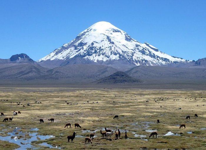
Nevado Sajama is an extinct stratovolcano and the highest peak in Bolivia. The mountain is located in the Oruro Department, Sajama Canton. The undergound mountains discovered by Princeton scientists are much taller.
Credit: Léo Guellec – Flickr, Wikipedia, CC BY-SA 2.0
The researchers were surprised by just how rough that boundary is — rougher than the surface layer that we all live on. “In other words, stronger topography than the Rocky Mountains or the Appalachians is present at the 660-km boundary,” said Wu. Their statistical model didn’t allow for precise height determinations, but there’s a chance that these mountains are bigger than anything on the surface of the Earth.
See also:
Mysterious Giant Ancient Network Of Underground Caves Discovered Beneath Montreal
Spectacular Tsingy: ‘Forest Of Limestone Neddles’, Deep Canyons And Underground Rivers
World’s Longest Underground River Flows Beneath The Yucatán Peninsula
Remarkable Rivers With Trees, Leaves And Waterfalls Hidden Under The Sea!
The roughness wasn’t equally distributed, either; just as the crust’s surface has smooth ocean floors and massive mountains, the 660-km boundary has rough areas and smooth patches. The researchers also examined a layer 410 kilometers (255 miles) down, at the top of the mid-mantle “transition zone,” and they did not find similar roughness.
Understanding the details of this subterranean mountain could decide the fate of various models describing the history of our planet’s constantly changing geology.
“What’s exciting about these results is that they give us new information to understand the fate of ancient tectonic plates which have descended into the mantle, and where ancient mantle material might still reside,” Irving said.
These underground mountains will certainly not be easy to explore and there is no hope we can find long-gone vanished animals or other creatures, but it’s an intriguing discovery that reminds us of lost worlds and the fact that there is still so much we can learn of what is hidden beneath our feet.
MessageToEagle.com
Related Posts
-
 Most Detailed Geological Model Reveals Earth’s Past 100 Million Years
-
 Sahara Can Be Green Again Thanks To New Wind And Solar Technology
-
 Masroor Temples – India’s Marvellous Ancient Cave Temples
-
 Lightning Strikes May Trigger Short-Term Thinning In The Ozone Layer
-
 Runaway West Antarctic Ice Retreat Can Be Slowed By Climate-Driven Changes In Ocean Temperature
-
 Mysterious 2000-Year-Old Carved Vishap Stone Monuments Of Armenia
-
 Sleeping More Than 8 Hours May Be A Sign Of Serious Illness
-
 Misplaced Piece of North America’s Continent Found In Australia – New Study
-
 Discovery Of Oldest Fossils Re-Writes History Of Bisons In North America
-
 Scientists Struggle To Find Out If Humans Really Had Fur Once And Why We Are So Hairless