
Ancient Mesopotamian City Lagash Reveals More Archaeological Secrets
Jan Bartek – MessageToEagle.com – Archaeologists have previously discovered that the ancient Mesopotamian city of Lagash, which flourished nearly 5,000 years ago between the Tigris and Euphrates rivers, was made of marsh islands.
“Anthropological archaeologist Emily Hammer of the University of Pennsylvania explained that remote-sensing data, mostly collected by a specially equipped drone, offers evidence a vast urban settlement called Lagash largely consisted of four marsh islands connected by waterways. These findings add crucial details to a growing consensus that southern Mesopotamian cities did not, as previously thought, expand outward from the temple and administrative districts into irrigated farmlands surrounded by a single city wall.
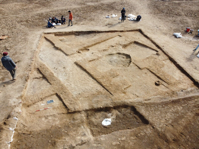
A drone photo of one of the site’s trenches, which shows two rectangular pits that held clay. Such finds provide further evidence that Lagash was a site where significant craft production took place. Credit: Lagash Archaeological Project
“There could have been multiple evolving ways for Lagash to be a city of marsh islands as human occupation and environmental change reshaped the landscape,” Hammer said.” 1
However, to scientists, this is just the beginning of archaeological discoveries of the ancient city of Lagash has to offer those who want to understand ancient history.
When Holly Pittman and colleagues from the University of Pennsylvania and the University of Pisa returned to Lagash in the fall of 2022 for a fourth season, they knew they’d find more than ceramic fragments and another kiln. With high-tech tools in hand, the team precisely located trenches to excavate a variety of features of a non-elite urban neighborhood from one of southwest Asia’s earliest cities.
What surprised the researchers most was the large “tavern” they uncovered, complete with benches, a type of clay refrigerator called a “zeer,” an oven, and the remains of storage vessels, many of which still contained food. “It’s a public eating space dating to somewhere around 2700 BCE,” says Pittman, a professor in Penn’s History of Art department, curator of the Penn Museum’s Near East Section, and the Lagash project director. “It’s partially open air, partially kitchen area.”
The find provides another glimpse into the lives of everyday people who dwelled some 5,000 years ago in this part of the world, an area Penn researchers have studied since the 1930s when the Penn Museum teamed up with Leonard Woolley and the British Museum to excavate the important archaeological site of Ur about 30 miles to the southwest. In 2019, the latest round of Lagash excavations began, and despite a short pandemic-necessitated pause, the project has real momentum, with four field seasons now complete.
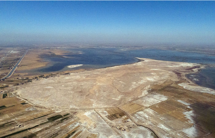
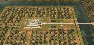
Holly Pittman and a team of researchers studying the archaeological site of Lagash, seen at bottom center, hypothesize that the ancient city was likely a significant population center that had ready access to fertile land and people dedicated to intensive craft production. Credit: Courtesy of Lagash Archaeological Project
To excavate most effectively, the researchers are employing cutting-edge methodologies, including drone photography and thermal imaging; magnetometry, which captures the magnetic intensity of buried features; and micro-stratigraphic sampling, a surgically precise type of excavation. To understand the city’s environmental context, they’ve also extracted sediment cores that reflect millennia of ecological development.
“At more than 450 hectares, Lagash was one of the largest sites in southern Iraq during the 3rd millennium,” Pittman says. “The site was of major political, economic, and religious importance. However, we also think that Lagash was a significant population center that had ready access to fertile land and people dedicated to intensive craft production. In that way the city might have been something like Trenton, as in ‘Trenton makes, the world takes,’ a capital city but also an important industrial one.”
A return to Lagash
During the fourth millennium BCE, about 6,000 years ago, the mouth of the Persian Gulf lay some 150 miles farther northwest than it does today. Close to that ancient shoreline sat a trio of settlements—Girsu, Lagash, and Niĝin—which together made up the larger city-state also known as Lagash. For more than 150 years, the three cities were unified as a single powerful and wealthy political entity.
Initially, archaeologists believed that the site of Girsu was Lagash. Then, in 1953, a surface inscription revealed the ancient city’s true location, at a spot called Tell al-Hiba, named after the nearby village. In the 1960s and ’70s, a team led by Donald Hansen of NYU’s Institute of Fine Arts and Vaughn Crawford of the Metropolitan Museum of Art completed five field seasons at the ancient city focusing on monumental and administrative architecture.
The Iran-Iraq War ended that work and, save for a UCLA survey in 1984, the site remained untouched until 1990, when Hansen and colleagues returned. That group included Pittman, a former student of Hansen’s who was then a newly minted associate professor at Penn. “Donald and I walked around the site and fantasized that we would start a new campaign, and it would be NYU and Penn and we would go together,” Pittman recalls.
After that single season, however, the First Gulf War halted research again. Though Pittman continued working in the Middle East for the next several decades—including analyzing and publishing the results of Hansen’s Lagash fieldwork after he died—it wasn’t until 2017 that she approached the State Board of Antiquities and Heritage (SBAH) in Iraq for a permit to resume work at the site.
Around that time, Zaid Alrawi had been interviewing for a postdoctoral position at the Penn Museum when he ran into Ph.D. student Reed Goodman, a former classmate now working with Pittman. “He told me about Holly and the project she wanted to resume at Lagash,” Alrawi says, “that she was looking for help from someone who spoke Arabic and who knew archaeology.”
Alrawi, originally from Iraq, had recently completed a Ph.D. in landscape archaeology at Penn State University; Goodman made the connection, and two weeks later, Alrawi and Pittman were on a plane. “We visited a few sites, starting with Lagash,” Alrawi says. “That brought Holly a lot of emotion. We went to the collapsed dig house where she had stayed previously. It was a special time. It showed me she wasn’t a random director who wanted to start a project—there was history there—and that mattered to me almost before anything else.”
Following that December 2018 visit, the rest of the team came together quickly, with Pittman at the helm and Alrawi as project manager. Augusta McMahon, then at the University of Cambridge and now at the University of Chicago, joined as field director, along with SBAH representatives and a dozen faculty and students, including Goodman. In March 2019, they had their first field season. “Nobody on the team had worked in Iraq for a long time,” Pittman says. “But it was an extraordinarily successful season. We came back with a lot of information and ideas about how we wanted to go forward.”
Since then, the University of Pisa’s Sara Pizzimenti has become field director, taking over the role during the most recent season. Goodman has returned three times, and a handful of other Penn graduate students have participated in various aspects of the project, including supervising excavations, registering small finds, and drawing thousands of pottery sherds.
The kilns and craft production
The Lagash settlement runs about three miles from north to south and one mile across, making it one of the biggest archaeological sites in southern Mesopotamia. Just beneath its surface lies evidence that can help reconstruct the lives of everyday people during what’s known as the Early Dynastic period, a 600-year stretch from 2900 to 2300 BCE, when some of the world’s first cities found their form.
During that first season, in the southern part of the site, the team noticed clear evidence of prior burning on a high rise, including an ashy surface with waste materials from pottery manufacture. Under McMahon’s guidance, they opened a large, square trench, where they unearthed six ceramic kilns with oval pits made of baked mudbrick. No upper portions remained, but at the time, McMahon surmised the tops were likely domed, composed of the same mud and clay that lined them. Excavations in the spring and fall of 2022 revealed five more kilns.
To the archaeologists, the density of the kilns indicates significant ceramic production at Lagash, and, since their discovery, the structures have elicited many follow-up questions: For one, how was such craft production organized? Was it politically centralized or run by smaller, local communities? At what temperatures did the kilns operate? And what was their lifespan?
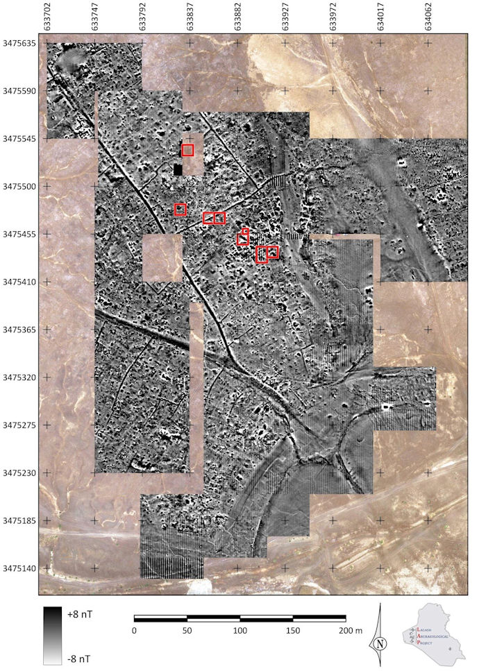
A portion of the site known as Area H, which sits in Lagash’s central-southern section, in a zone of low, discontinuous mounding. Here, magnetometry imaging from 2019 and 2022 seasons shows the magnetic intensity of buried features. Credit: Composite image: Paul Zimmerman/Lagash Archaeological Project
Answers to those queries alone could fill volumes, but the researchers have more, specifically about nearby architecture. Pittman says the kilns have likely survived for thousands of years—and so close to the surface, too—because they were hardened by fire. It’s increasingly clear that most of the surrounding streets, alleyways, and buildings predate the kilns, with millennia of rain, flooding, and wind erasing those that would have been contemporary.
Yet recent work suggests that at least one street and workspace align, timewise, with one kiln area. “We found two rectangular pits that seem to represent stages of ceramic production,” Pittman says. “One contained a pure red clay, which has ideal plastic qualities and is still used today. The other held a coarse yellow-green sand, which would serve as a tempering agent.”
An open space just west of these pits, likely also used by those same ceramic makers, contained benches and a table. In another square nearby, the team excavated what seems like a domestic dwelling that had a kitchen with clay jar stoppers, bowls with food, and a grinding stone on the floor, plus a toilet several rooms over. Each discovery reveals more about the people of Lagash.
Geological coring and water
The team is making similar inroads with its grasp of Lagash’s ancient environment. Scholars have hypothesized that the city was once much closer to the Persian Gulf, and as part of his doctoral research, Goodman is working to determine when and why that distance changed. “I’ve been looking at the relationship between urbanization in southern Iraq and changing waterscapes,” Goodman explains. “That’s how I fell in with Holly.”
In 2019, he conducted the first geoarchaeological studies at Lagash, using a handheld device called an auger to collect about 40 feet of sediment from 12 locations. More recently, the project teamed up with local drilling technicians to reach about 80 feet down. Getting to such depths has provided tens of thousands of years of environmental proxy information, covering the late Pleistocene, which began around 2.5 million years ago and ended approximately 11,700 years ago, and the Holocene, which directly followed the Pleistocene.
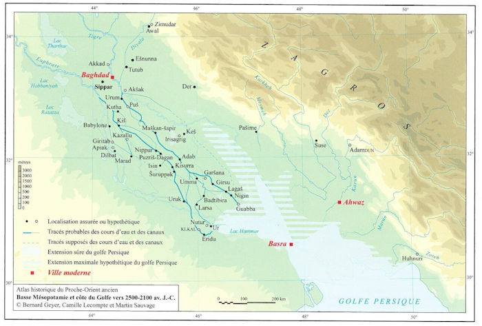
A map of southern Mesopotamia during the third millennium BCE, around 6,000 years ago. Credit: M. Sauvage Atlas
Goodman is studying the samples with Liviu Giosan of the National Ocean Sciences Accelerator Mass Spectrometry facility at Woods Hole Oceanographic Institution. This work includes measuring a sample’s elemental composition with X-ray fluorescence, as well as its carbon isotopic signatures to differentiate downstream sediment sources, plus investigating ancient organisms like foraminifera and ostracoda, which reflect fresh, brackish, and marine conditions.
“In the Pleistocene, southern Iraq was very different than today, with fast-flowing and deeply incised rivers,” says Goodman, who is in his final year of a Ph.D. in Penn’s Art and Archaeology of the Mediterranean World graduate group. Goodman and colleagues are finding that by Lagash’s heyday, as the heart of the Tigris-Euphrates delta migrated southeast, the climate shifted from wetter to drier, posing an increasing challenge for the local population.
Combining all this information, “we’ll see deltaic evolution in this ecological cauldron across centuries,” Pittman says. “This is something people have theoretically modeled, but we’re getting actual dates of water regime changes, which will be revolutionary. It’s environmental science at the cutting edge.”
A picture begins to emerge
Each discovery reveals another layer of the landscape and more about the people of ancient Lagash, enabled by what Alrawi calls a “modern” excavation approach. “It’s not like old-time archaeology in Iraq,” he says. “We’re not going after big mounds expecting to find an old temple. We use our techniques and then, based on scientific priority, go after what we think will yield important information to close knowledge gaps in the field.”
Craft production is one such example; so is knowing the proximity to the sea. But there are many others. “As you excavate, you analyze and create a story that we hope gets closer and closer to the reality of the past,” Alrawi says.
For her part, Pittman says she’s thrilled at the progress of this now well-oiled machine. “We’re all completely committed to the collective success of this project,” she says. “Iraq has suffered so profoundly for many years. I hope it will find stability and be able to enjoy and nurture its great and important antiquity. Our role is to help make that happen.”
That played out this past fall as the team uncovered the tavern. Rather than digging according to architectural construction phases, the Lagash Archaeological Project is using an approach championed by Pisa’s Pizzimenti, who excavates by microstratigraphic layers, thin lens by thin lens horizontally, across a wide swath, “like doing very careful surgery,” Pittman says. “Just 50 centimeters down, we were able to capture all of this. We were happily astounded.”
Pittman and her colleagues feel such a sentiment time and again at Lagash, an ancient settlement that was part of a network of ancient cities in Iraq, individual sites connected if not by physical proximity, then by economics and politics, industry and natural resources. A variety of artifacts there show the archaeological passing of time, and despite all that’s already been exposed or imaged, there’s still so much yet to learn.
Partnering with the community
Tell al-Hiba, the site of this archaeological excavation, is also a small village. “Giving back to this community is paramount,” says Holly Pittman, Lagash project director. For the primary school, the researchers helped facilitate a new courtyard, privacy wall, and bathrooms, and project manager Zaid Alrawi is working with locals he knows to identify other areas of critical need in the village.
See also: More Archaeology News
Through its website, the team also shares important discoveries, both in English and Arabic. “Ultimately,” Pittman says, “we’re striving to maximize synergy and symbiosis with our hosts, as the economic and intellectual stimulus from the research creates a fundamental network of commitment, trust, and, following years of neglect, recovery.”
For more information about the Lagash Archaeological Project, visit web.sas.upenn.edu/lagash.
Written by Jan Bartek – MessageToEagle.com – AncientPages.com Staff Writer
Expand for referencesRelated Posts
-
 Suontaka Weapon Grave: New Light On Strong Female Leaders And Warriors Of Late Iron Age Finland
-
 LIDAR Images Reveal Cambodia’s Greater Angkor Region Was Home To 700,000-900,000 People
-
 King Tut’s Cosmic Dagger Was Not Made In Egypt – New Study Reveals
-
 Is The Tomb Of Genghis Khan Hidden And Protected In The Khentii Mountains Because Some Fear It’s Cursed?
-
 Outrage In Egypt – Netflix’s Queen Cleopatra Movie Is A Falsification Of Egyptian History
-
 Long-Lost Burial Site Of Viking King Harald Bluetooth Discovered By Satellites?
-
 Unusual And Well-Preserved Skeleton Discovered In Ancient Pompeii Sheds New Light On The Cultural Life Of The City
-
 10 Ancient Love Symbols
-
 Previously Unkown Manuscript Reveals New Insight Into Medieval Christian Beliefs In England
-
 Huge Subterranean Pre-Columbian Shaft Tombs In Tierradentro, Colombia